By Roland Burchuladze (Tbilisi State University of Language and Culture)
At the present stage of Urartology it is acknowledged that in Assyrian sources the term Urartu is mentioned in two aspects:
1) as a term that signified the territory situated to the North of Assyria, but without specifying its geographical boundaries, and
2) as a state already existing in 9 to 7 B.C. to the North of Assyria – but again, without specifying its geographical and political borders (E. Ebeling, B. Meissner, E.F. Weidnet, Die lnschriften der altassyrischen Konige, 1926., J. Lewy, Studies in the Historic Geography of the Ancient Near East, „Orientalia“, vol. 21, fasc. 4, 1952., D.D. Zuckenbill, Ancient Records of Assyria and Babylonia., Z. Waterman, Royal Correspondence of the Assyrian Empire, I-IV).
Concerning the origin of Urartu – as a concept and/or term – this issue has already been clearly defined as an opinion that „It is difficult to find the etymology of the term (Urartu) in Semitic-Assyrian world“ (T. ![]() T6., 1954).
T6., 1954).
Yet, this opinion needs some additional clarification, after stating several times that North-West Semitic tribes existed in the Caucasus (R. Burchuladze, Interpretation of a Comment by Herodotus, Studies in Typology, R. Burchuladze, To the Problems of Toponymics of Old Tbilisi /“Tabori“/, Problems of History and Theory of Culture, XIII, 2002., D. Lomitashvili, Nokalakevi – I, Culture of Ancient Workshops and Settlements /Beadmaking Workshop in Nokalakevi, Kolkhuri-Egyptian Analogues, Problems of History and Theory of Culture, 2002., R. Burchuladze, Egyptian Hieroglyphics and Etymology of‘ Abkh ai and Kavkasi, Historical Studies, III, 2002).
The problem at the present stage is only a matter of chronology, and we believe that the solving of the problem must be preceded by the study of onomastics of the Near East from the aspect of Semitic languages. This is explained simply by the reason that the Semites seem to have been the ancient civilized population of the territory, whereas Indo-Europeans and people of Turkish origin represent a result of waves of migration at a later period.
Historians perceive the history of every nation in direct connection with a particular geographic location. This is explained by the simple reason that any aspect of the development of society is firmly linked with the territory where a sotium is conceived and developed. Economics represents a basic driving force of human society, and its development depends to a considerabe extent on the geographic area, where the process is taking place.
The features of the geographic environment not only influence the human life and mentality, but they also manage to leave an ineffaceable trace on not a few pages of the history of civilization by projecting it on the matter of language.
The above-mentioned can be proven most perfectly by the example of Egypt. One can hardly point to any other geographical environment which still resembles – at least slightly- the area, where centuries ago Egyptian civilization was conceived and developed, the one that many scientists reasonably consider the first and inimitable stage of human civilization.
It is definitely impossible to find another territory in the world that will prove so isolated from the outside world on all sides, as Egypt is, having the Nile – its foremost and only artery of vital importance and necessity – water.
A living body cannot exist without water and this truism is even more justified with regard to human civilization. Calling the Nile a divine river was not accidental. Not only the civilization of Egypt, but also the fauna and flora of the river’s middle part and its delta all depended on the Nile water. As a result of that, for Egyptians every day was determined by the level of the Nile water.
On the other hand, the existing conditions determined their orientation to the South: the Nile flowed from the South. That was why all of Egypt, with unyielding tension and hope, was staring upstream, across the rapids, where the river-head of the Nile was supposed to exist.
Due to this situation, this Egyptian system of environment planning was oriented towards the upstream of the Nile, because they still did not know the location of the source of the river. Thus, this situation explains why the geographic maps, characteristic of the Semitic world, were oriented to the South.
The direction of the Nile flow also determined the corresponding designations of the political entities, which were named according to their location – Upper Egypt and Lower Egypt.
A number of questions related to the civilization of Old Egypt still requires study and more accurate definition, but the set of issues already mentioned provides the reasons to conclude that during the entire period of its existence, Egypt had been in close contact with the outside world, incessantly trying to broaden the horizons of the world already known and real. Those great expeditions by sea, which had been carried out during the reign of Hatshepsut and Nekho, provide concrete proof for this statement. Yet, those achievements are attributed to a rather later period of Egyptian history, and both voyages were taken in the direction of the South. This particular point signifies that by that time the northern direction had already been assimilated. Thus the interests of Egypt turned to the matter of the more distant areas in the South.
On this point a question arises: What was the specific Egyptian policy and on what was it based – in terms of the assimilation process of the Mediterranean aquatoria?
The study of this problem encompasses a rather narrow circle of the relative sources. Moreover, those sources mostly describe the relations between the Phoenicean cities.
This state of affairs attracted our attention to an appropriate feature of Egyptian hieroglyphics: its graphic aspect, which is aimed at copying the universe – whether organic or inorganic – that was characteristic of the geographical realm of ancient Egypt. Naturally, the said element dictates the perception of the reasons that ensured the creation of hieroglyphic system as well as the further study of the optional directions of their functioning.
When they began to create the hieroglyphic system, the Egyptians had already learned and assimilated the peculiarities of the geographic environment in which they had to spend their life.
For this reason they selected the papyrus ![]() as the hieroglyphic symbol of Lower Egypt and a lotus
as the hieroglyphic symbol of Lower Egypt and a lotus ![]() – for Upper Egypt.
– for Upper Egypt.
These examples clearly demonstrate that a hieroglyphic sign expresses a particular feature or quality of an object existing in nature, and for that reason it implements and retains its communicative function.
Another interesting example can help reenforce this line of reasoning: ![]() hieroglyph, with its phonetic meaning of r signifies mouth. This is because the r vibrant – when compared to other sounds – is the best to embody the pronounced sound. The fact that r and I had been constantly mixed (misused) in the history of Egyptian hieroglyphics and its functioning is explained through phonetics: both r and I making a sonorous pair.
hieroglyph, with its phonetic meaning of r signifies mouth. This is because the r vibrant – when compared to other sounds – is the best to embody the pronounced sound. The fact that r and I had been constantly mixed (misused) in the history of Egyptian hieroglyphics and its functioning is explained through phonetics: both r and I making a sonorous pair.
Hieroglyphic sign of ![]() – lion. that signifies I, is a symbol easy to grasp: not only because of repeating the sound of I according to acrophony (lo, lio, leo), but also because of the association of the sound r to a lion’s roar.
– lion. that signifies I, is a symbol easy to grasp: not only because of repeating the sound of I according to acrophony (lo, lio, leo), but also because of the association of the sound r to a lion’s roar.
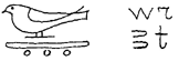
In view of the above-mentioned, our attention was attracted by the ![]() hieroglyph with its phonetical meaning of wr, which signifies swallow and big at the same time.
hieroglyph with its phonetical meaning of wr, which signifies swallow and big at the same time.
This particular case demonstrates the phonetic significance, which can be interpreted as a case of onomatopoeia, since this pair of sounds – wr-ur – has a great resemblance to the twittering of a swallow.
As for the lexical meaning, the first needs no explanation, since the hieroglyph shows a graphic image of a swallow. The second meaning, however, needs a bit of explanation. The concept of big in general is linked with the visual perception of an object. From this point of view, another factor needs to be taken into consideration: a swallow belongs to the family of sparrows, but because of its wings and a tail, it certainly seems bigger than a sparrow. Thus the meaning of wr as swallow and big can be understood.
The area of the swallows‘ habitat is very wide. It belongs to the migratory birds and spends the hatching or nesting period in countries of moderate climate – to leave them with the oncoming of winter.
On the other hand, swallows, being permanent dwellers in Egypt, are not considered migratory birds there. The process of migration can be observed from the 33 parallel. This fact is very important, because it prompts us to consider the general scene not only of Egypt, but also of the entire territory, which was inhabited/populated by North-Western Semites – Egyptians, Jews and Phoenicians.
Therefore, if we attribute the territory of Phoenicia to the zone of swallow migration, what kind of perceptions could be developed among the Semites who populated the region. They were constantly witnessing the swallows‘ „departure“ to the North at the appropriate season of the year – to come back with their nestlings/fledglings/chicks. The unvarying repetition of the process gave Egyptians, Jews and Phoenicians reason to conclude that a country existed in the North that could be considered the homeland of swallows, because it was the very place of their propagation/reproduction. So, for the North-Western Semites, that land, which was still unfamiliar to them and about which they had only a vague idea, based on their lengthy observation, could bear only the name: the land of swallows. In hieroglyphic writing, this term can be presented in the following way
1.)
2.)
The wr ![]() determinative here signifies the plural form and is not pronounced.
determinative here signifies the plural form and is not pronounced.
The evidence above allows us to make a definite conclusion: The territory situated somewhere in the North, beyond the 33° parallel, was to be named the land of swallows. Later, the Semites, who explored that territory and settled there, called those people who did not cut their links with their initial region of life (i.e. Egypt and Phoenicea) and led a migratory life and existence – swallows – wr.
This name – wr – swallow, clearly shows us not only the origin and derivation of ur – settlements on the vast territory of the Near East, but also clarifies the name so widespread – of those settlers and their descendents: uria.
Now let us come back to the matter of the land of swallows‘ hieroglyphics:
As we have already mentioned, the term is in plural form but expressing the same term in singular is also possible:
This form deserves particular attention, because Indo-European Armens who subsequently populated the territory to the South of Caucasia, called the Caucasian Kartes living in the North – wrats, the term they used in speech and in written sources as well. Thus, the same root is used here as an ethnonyme that is present in wr, land of swallows – the name given by Egyptians.
This example is used to propound again categorically the fact that prior to the coming of Indo-Europeans to Caucasia, the Semitic element was active in this region.